File:HRR 1648.png
Size of this preview: 736 × 600 pixels. Other resolutions: 295 × 240 pixels | 589 × 480 pixels | 942 × 768 pixels | 1,256 × 1,024 pixels | 2,513 × 2,048 pixels | 4,857 × 3,959 pixels.
Original file (4,857 × 3,959 pixels, file size: 3.22 MB, MIME type: image/png)
Summary
| Description |
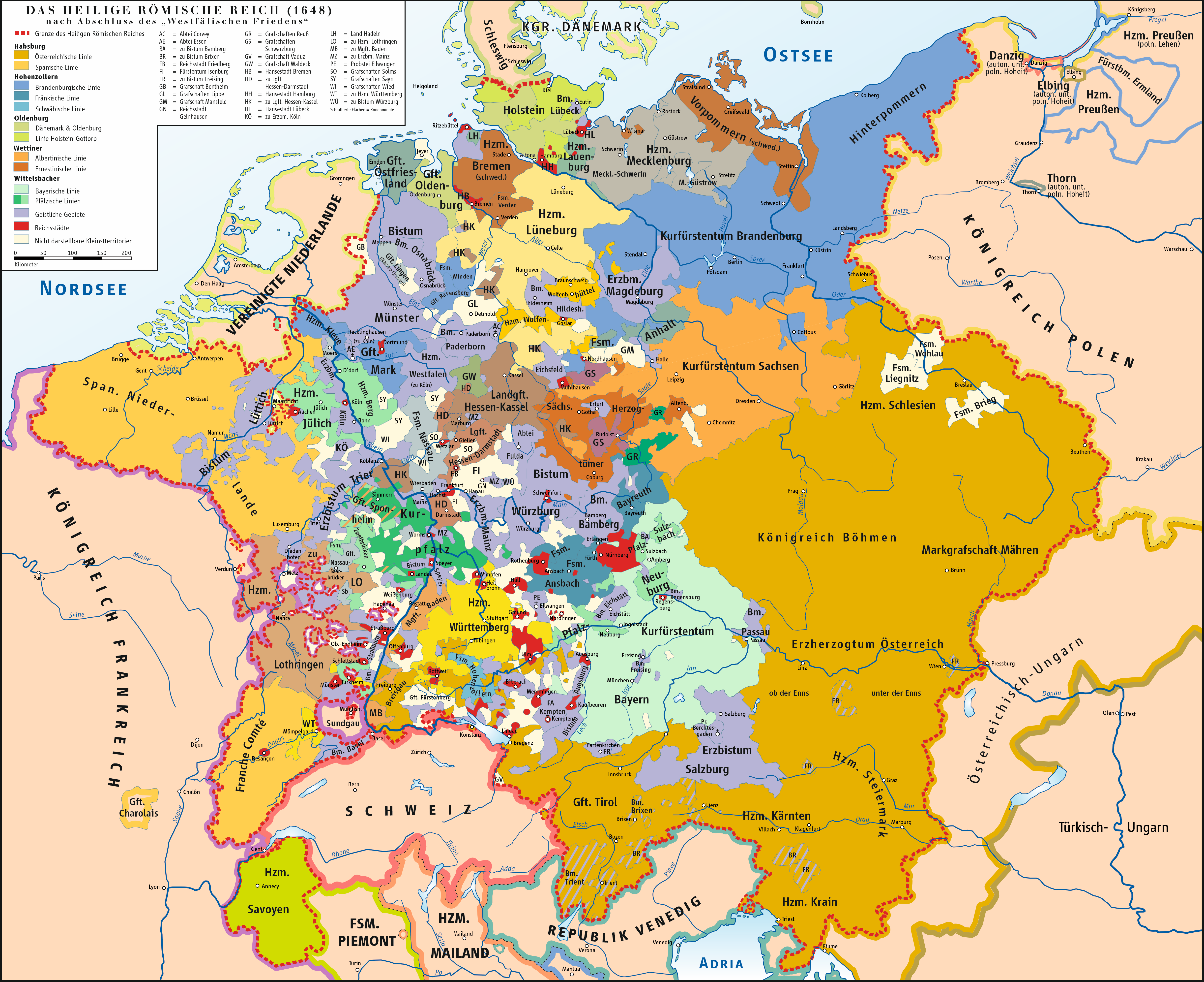
Deutsch: Karte des Heiligen Römischen Reiches 1648
English: Map of Holy Roman Empire 1648 |
|||||||||
| Date | ||||||||||
| Source | own drawing/Source of Information: Putzger – Historischer Weltatlas, 89. Auflage, 1965; Westermanns Großer Atlas zur Weltgeschichte, 1969; Haacks geographischer Atlas. VEB Hermann Haack Geographisch-Kartographische Anstalt, Gotha/Leipzig, 1. Auflage, 1979. | |||||||||
| Creator | ||||||||||
| Geotemporal data | ||||||||||
| Bounding box |
|
|||||||||
| Georeferencing | ||||||||||
| Other versions |
|
|||||||||
.png)


Licensing
I, the copyright holder of this work, hereby publish it under the following licenses:

|
Permission is granted to copy, distribute and/or modify this document under the terms of the GNU Free Documentation License, Version 1.2 or any later version published by the Free Software Foundation; with no Invariant Sections, no Front-Cover Texts, and no Back-Cover Texts. A copy of the license is included in the section entitled GNU Free Documentation License. |
| This file is licensed under the Creative Commons Attribution-Share Alike 3.0 Unported license. | ||
| ||
| This licensing tag was added to this file as part of the GFDL licensing update. |
This file is licensed under the Creative Commons Attribution 2.5 Generic license.
- You are free:
- to share – to copy, distribute and transmit the work
- to remix – to adapt the work
- Under the following conditions:
- attribution – You must give appropriate credit, provide a link to the license, and indicate if changes were made. You may do so in any reasonable manner, but not in any way that suggests the licensor endorses you or your use.
You may select the license of your choice.
File history
Click on a date/time to view the file as it appeared at that time.
| Date/Time | Thumbnail | Dimensions | User | Comment | |
|---|---|---|---|---|---|
| current | 11:39, 31 January 2025 | | 4,857 × 3,959 (3.22 MB) | wikimediacommons>Ziegelbrenner | Corrected Ticino |
File usage
The following 2 pages use this file: