File:Mediterranean1400.png
Size of this preview: 799 × 361 pixels. Other resolutions: 320 × 145 pixels | 640 × 289 pixels | 1,215 × 549 pixels.
Original file (1,215 × 549 pixels, file size: 187 KB, MIME type: image/png)
Summary
| Description |
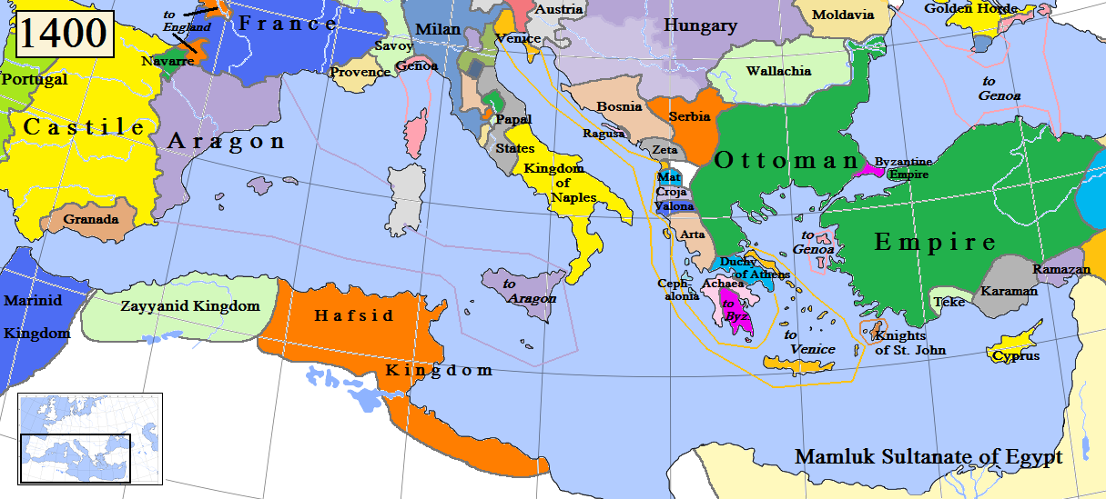
English: Map of the Mediterranean region in AD 1400. (Partially based on Euratlas map of Europe, 1400.)
(NOTE: THIS MAP IS RATHER PROVISORY AND INACCURATE!!! THE AUTHOR SHOULD MAKE IT BETTER! HE COULD USE FOR INSTANCE THE FOLLOWING MAP ON THE WIKIMEDIA COMMONS:  (MADE BY GUSTAV DROYSEN IN 1886, VERY MUCH ACCURATE) OR OTHER SUCH OR SIMILAR MAPS. (MADE BY GUSTAV DROYSEN IN 1886, VERY MUCH ACCURATE) OR OTHER SUCH OR SIMILAR MAPS. |
| Date | |
| Source | Own work |
| Author | Gabagool |

|
This map image could be re-created using vector graphics as an SVG file. This has several advantages; see Commons:Media for cleanup for more information. If an SVG form of this image is available, please upload it and afterwards replace this template with
{{vector version available|new image name}}.It is recommended to name the SVG file “Mediterranean1400.svg”—then the template Vector version available (or Vva) does not need the new image name parameter. |
Licensing
I, the copyright holder of this work, hereby publish it under the following license:
This file is licensed under the Creative Commons Attribution 3.0 Unported license.
- You are free:
- to share – to copy, distribute and transmit the work
- to remix – to adapt the work
- Under the following conditions:
- attribution – You must give appropriate credit, provide a link to the license, and indicate if changes were made. You may do so in any reasonable manner, but not in any way that suggests the licensor endorses you or your use.
File history
Click on a date/time to view the file as it appeared at that time.
| Date/Time | Thumbnail | Dimensions | User | Comment | |
|---|---|---|---|---|---|
| current | 12:02, 19 April 2009 | | 1,215 × 549 (187 KB) | wikimediacommons>Gabagool | Some corrections. |
File usage
The following page uses this file: