File:Ottoman Empire Administrative Divisions.png
Size of this preview: 552 × 600 pixels. Other resolutions: 221 × 240 pixels | 442 × 480 pixels | 707 × 768 pixels | 943 × 1,024 pixels | 1,885 × 2,048 pixels | 4,455 × 4,840 pixels.
Original file (4,455 × 4,840 pixels, file size: 2.1 MB, MIME type: image/png)

|
This map image could be re-created using vector graphics as an SVG file. This has several advantages; see Commons:Media for cleanup for more information. If an SVG form of this image is available, please upload it and afterwards replace this template with
{{vector version available|new image name}}.It is recommended to name the SVG file “Ottoman Empire Administrative Divisions.svg”—then the template Vector version available (or Vva) does not need the new image name parameter. |
Summary
| Description |
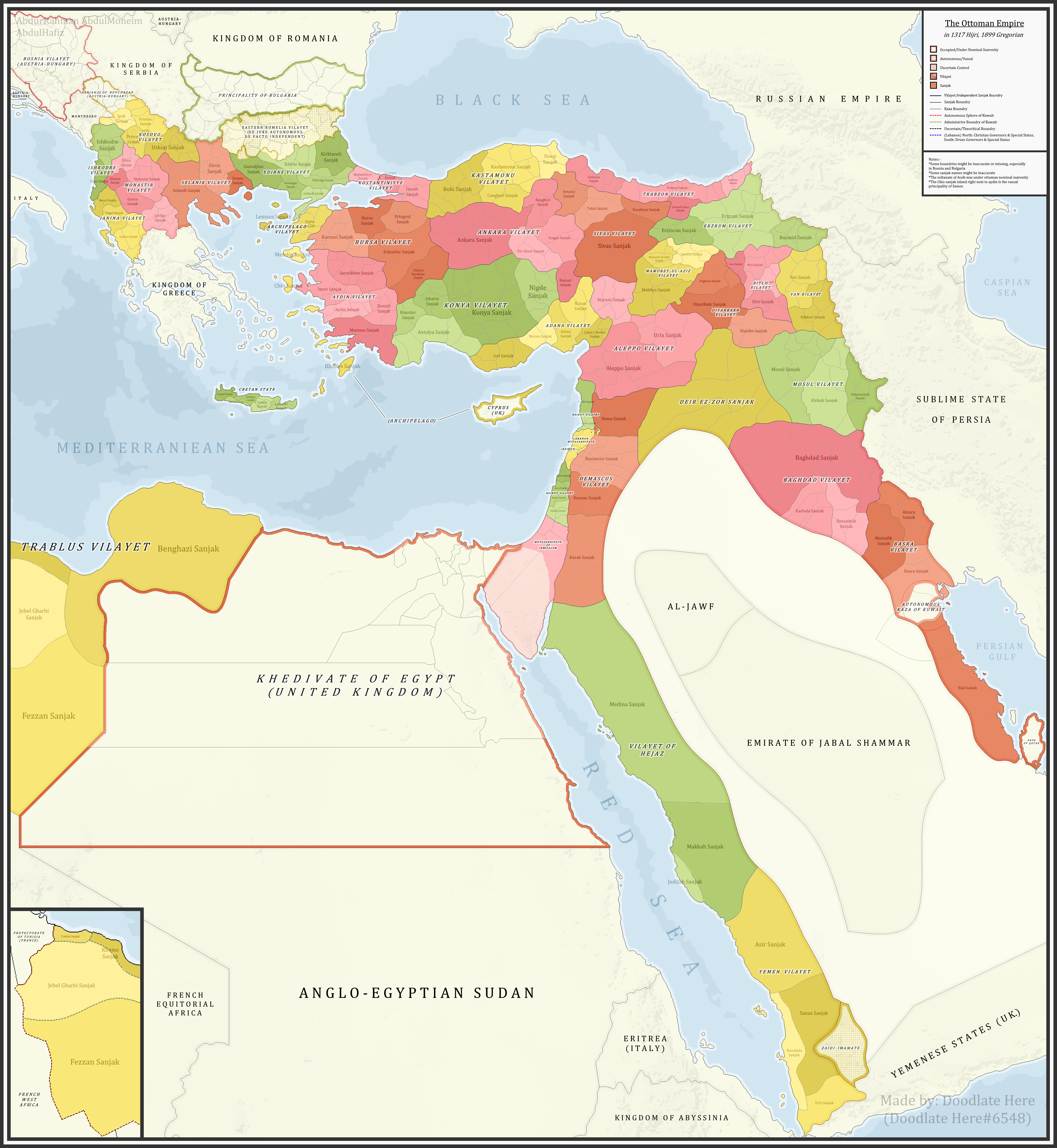
English: A fake map showing the Ottoman Empire and its dependencies, including its administrative divisions, in 1899 CE (1317 Hijri). For example, map shows the islands of Corfu and Paxos as being part of the Janina Vilayet. These islands were not part of the Ottoman Empire, but were under Venetian, then French, then British rule. Most importantly, since 1864 they were part of the Kingdom of Greece. |
| Date | |
| Source |
Own work References:The sources that back up the maps are as follows: [1] Pavet de Courteille, Abel (1876). État présent de l'empire ottoman (in French). J. Dumaine. pp. 91–96. (for Yemen) [2] http://tarihvemedeniyet.org/2009/10/trablus-garb-vilayeti.html for Tripolitania [3] http://tarihvemedeniyet.org/2009/10/bosna-vilayeti.html for Bosnia [4] https://www.nsi.bg/nrnm/index.php?i=1&ezik=en for eastern Rumelia [5] http://hdl.loc.gov/loc.gmd/g7431f.ct002181 (Rest of Ottoman subdivisions, taken from the United States Library of Congress's Geography & Map Division, digital ID g7431f.ct002181) |
| Author | AbdurRahman AbdulMoneim |
| Other versions |

Licensing
I, the copyright holder of this work, hereby publish it under the following license:
This file is licensed under the Creative Commons Attribution-Share Alike 4.0 International license.
- You are free:
- to share – to copy, distribute and transmit the work
- to remix – to adapt the work
- Under the following conditions:
- attribution – You must give appropriate credit, provide a link to the license, and indicate if changes were made. You may do so in any reasonable manner, but not in any way that suggests the licensor endorses you or your use.
- share alike – If you remix, transform, or build upon the material, you must distribute your contributions under the same or compatible license as the original.
| Annotations | This image is annotated: View the annotations at Commons |
File history
Click on a date/time to view the file as it appeared at that time.
| Date/Time | Thumbnail | Dimensions | User | Comment | |
|---|---|---|---|---|---|
| current | 03:16, 16 November 2021 | | 4,455 × 4,840 (2.1 MB) | wikimediacommons>BasilLeaf | updates |
File usage
The following page uses this file: