File:SSS Islands Map.png

Size of this preview: 466 × 600 pixels. Other resolutions: 186 × 240 pixels | 527 × 678 pixels.
Original file (527 × 678 pixels, file size: 88 KB, MIME type: image/png)
Summary
| Description |
Nederlands: Bovenwindse Eilanden (Anguilla, Saint-Martin/Sint Maarten, Saint-Barthélemy, Saba, Sint Eustatius
Polski: Mapa środkowej części Wysp Podwietrznych (Anguilla, Saint-Martin/Sint Maarten, Saint-Barthélemy, Saba, Sint Eustatius
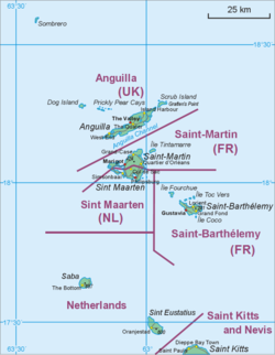
English: Map of middle part of Leeward Islands (Anguilla, Saint-Martin/Sint Maarten, Saint-Barthélemy, Saba, Sint Eustatius |
|||
| Date | ||||
| Source | Own work | |||
| Author | Hanhil based on File:Saint Martin Map.png by Aotearoa | |||
| Other versions |
|
.png)


Licensing
I, Hanhil, the copyright holder of this work, hereby publishes it under the following licenses:

|
Permission is granted to copy, distribute and/or modify this document under the terms of the GNU Free Documentation License, Version 1.2 or any later version published by the Free Software Foundation; with no Invariant Sections, no Front-Cover Texts, and no Back-Cover Texts. A copy of the license is included in the section entitled GNU Free Documentation License. |
| This file is licensed under the Creative Commons Attribution-Share Alike 3.0 Unported license. | ||
Attribution:
I, Hanhil | ||
| ||
| This licensing tag was added to this file as part of the GFDL licensing update. |
You may select the license of your choice.
File history
Click on a date/time to view the file as it appeared at that time.
| Date/Time | Thumbnail | Dimensions | User | Comment | |
|---|---|---|---|---|---|
| current | 05:34, 10 November 2020 | | 527 × 678 (88 KB) | wikimediacommons>Hanzlan | Saint-Barthélemy instead of Saint-Barthélémy |
File usage
The following page uses this file: