File:Swedish Empire.svg

Size of this PNG preview of this SVG file: 547 × 600 pixels. Other resolutions: 219 × 240 pixels | 438 × 480 pixels | 701 × 768 pixels | 934 × 1,024 pixels | 1,868 × 2,048 pixels.
Original file (SVG file, nominally 800 × 877 pixels, file size: 513 KB)
Summary
| Description |
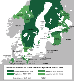
English: Map showing the Swedish Empire at its peak along with when it conquered the territories they controlled and also when they lost the territories they lost. |
| Date | |
| Source |
Derived from: File:Swedish_Empire_(1560-1815)_blank.svg |
| Author |
Charles (Chhrls) Memnon335bc |
_blank.svg)
Licensing
This file is licensed under the Creative Commons Attribution-Share Alike 3.0 Unported license.
- You are free:
- to share – to copy, distribute and transmit the work
- to remix – to adapt the work
- Under the following conditions:
- attribution – You must give appropriate credit, provide a link to the license, and indicate if changes were made. You may do so in any reasonable manner, but not in any way that suggests the licensor endorses you or your use.
- share alike – If you remix, transform, or build upon the material, you must distribute your contributions under the same or compatible license as the original.
File history
Click on a date/time to view the file as it appeared at that time.
| Date/Time | Thumbnail | Dimensions | User | Comment | |
|---|---|---|---|---|---|
| current | 02:56, 6 February 2021 | | 800 × 877 (513 KB) | wikimediacommons>Chhrls | Updated borders for places like the Swedish-Finnish border and the Skåne-Blekinge border, added Blekinge, changed incorrect dates for places like Swedish Pomerania. |
File usage
The following page uses this file: