File:Confluence of the Tigris and Euphrates near Al-Qurnah.tif

Size of this preview of this TIF file: 800 × 482 pixels. Other resolutions: 320 × 193 pixels | 640 × 386 pixels | 1,024 × 617 pixels | 1,280 × 771 pixels | 2,400 × 1,446 pixels.
Original file (2,400 × 1,446 pixels, file size: 1.88 MB, MIME type: image/tiff)

|
File:Confluence of the Tigris and Euphrates near Al-Qurnah.svg is a vector version of this file. It should be used in place of this TIF file when not inferior.
File:Confluence of the Tigris and Euphrates near Al-Qurnah.tif → File:Confluence of the Tigris and Euphrates near Al-Qurnah.svg
For more information, see Help:SVG. |
 |
Summary
| Description |
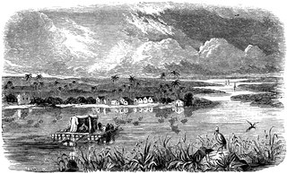
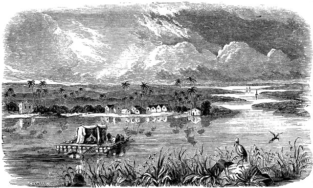
English: “In their upper course the Euphrates and the Tigris traverse a region of steppes broken by rocky ridges and interspersed with pastures and fruitful districts. The banks of the rivers are fringed with plane-trees, tamarisks, and cypresses. Here and there are meadowlands, alternating with low hills. Further on, as the rivers descend to the level, the valleys broaden; but at the same time the higher district between becomes more sterile kind of upland waste, abounding in ostriches and bustards, the native home of wild asses and nomadic tribes of men."—Ridpath, 1885 |
| Date | |
| Source | Ridpath, John Clark (1885) Encyclopedia of Universal History Cincinnati, OH: The Jones Brothers Publishing CO. |
| Author | Ridpath, John Clark |
| Other versions |
|
| Camera location | | View this and other nearby images on: OpenStreetMap |
|---|
Licensing
|
This work is in the public domain in its country of origin and other countries and areas where the copyright term is the author's life plus 70 years or fewer. This work is in the public domain in the United States because it was published (or registered with the U.S. Copyright Office) before January 1, 1930. | |
| This file has been identified as being free of known restrictions under copyright law, including all related and neighboring rights. | |
File history
Click on a date/time to view the file as it appeared at that time.
| Date/Time | Thumbnail | Dimensions | User | Comment | |
|---|---|---|---|---|---|
| current | 14:26, 11 April 2021 |  | 2,400 × 1,446 (1.88 MB) | wikimediacommons>Jup567 | Uploaded a work by Ridpath, John Clark from Ridpath, John Clark (1885) Encyclopedia of Universal History Cincinnati, OH: The Jones Brothers Publishing CO. with UploadWizard |
File usage
The following page uses this file: